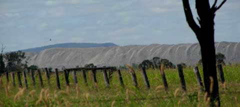
As central Queensland floods, I am hearing much in the media about the economic damage to the coal mines there, but not what those mines are contaminating as the floods surge through them. Or as the exposed coal stockpiles at every mine, rail loader and port loader wash into the floods.
When the town of Theodore was evacuated, I immediately thought of the flatness of the country and the road to Theodore, which runs for kilometres beside the Moura mine’s heavy metal-laden overburden dumps, now washing into the rushing flood, and of their contaminated mine water, usually stored in earth-walled tailings dams.
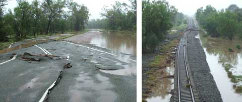
And if you ever thought road and rail were solid things, just look at how they have been pushed aside by water — lifted like frosting on a cake, as shown by this photo of the Banana to Theodore route, passed on by Avriel Tyson from near Rolleston.
What will such power have done in all the mines up there?
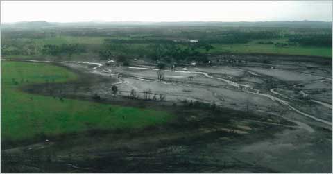
In previous floods, such walls have broken or been overflowed, and mines fined (tuppence!), as at the Ensham and Rolleston mines in the Emerald region, for releasing these toxic waste waters into the river system — and hence to the Great Barrier Reef. This photo, of the Rolleston mine flooding in that previous event, was taken by Avriel Tyson.
The Tysons have been isolated on their homestead island of slightly higher ground (which I had thought was flat when I was there) by the current unprecedentedly high flooding since late December, creeks breaking their banks that never have before, their road washed away — one of their heifers turning up 20 kilometres away! — and they are told that the next-door mine has had two metres of water over its railway line.
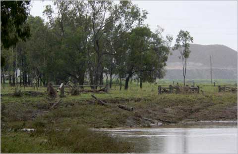
As the waters dropped, Avriel took photos of flooded Sandy Creek near their boundary, with the Xstrata mine behind.
Tysons have been here for over 100 years but Avriel says that this is a first; that the normal flood direction is baulked by the mine’s ‘ring tank levees and overburden piles’.
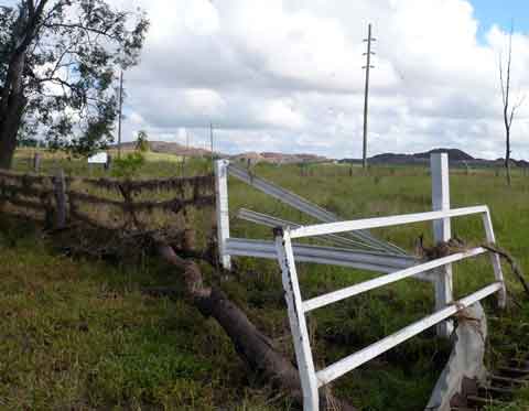
She wonders what the mine is doing with its water, and, looking at the debris on the fence and grid at their boundary with the mine, I too wonder what invisibles the mine has deposited.
Farmers expect to work with flood plain systems, mines can’t.
There are about 40 mines in the Bowen Basin, many of which interfere with the natural spread and flow system of floodwaters, their massive earthworks blocking and channelling so the plain no longer functions as nature designed.
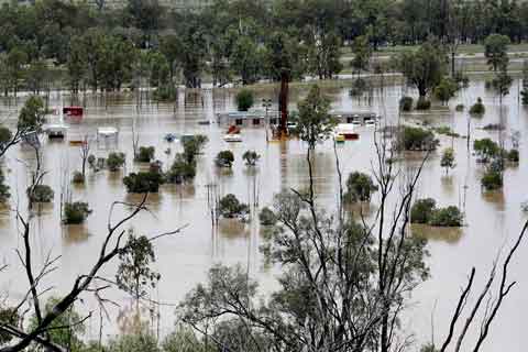
In the Surat Basin, increasingly sieved with a network of gas wells and test bore holes — Taroom, Chinchilla, Dalby — what will the aftermath damage be from all the submerged and tumbled drilling sites and pipelines? The photo above, passed on by Avriel, is on the Taroom/Roma road.
Mine management ‘plans’ for hazardous materials and wastes may tick the government boxes for approval but they only work on paper, not on the flood plains. Thirty more mines are planned for the Bowen Basin in the next five years, and half of the existing 40 are expanding.
Poisoned river systems, poisoned silt deposited on farmland? We need to hear from the mining industry how they are dealing with this aspect of multliple flooded mines, not just how it will hurt their profit margins.
Following a reply from Nathan, I see the story is out in the papers: mines are being allowed to release, but only one gas miner has applied so far. See the story in the Courier Mail:
http://www.couriermail.com.au/news/queensland/inundated-coal-mines-pump-residue-tainted-water-into-the-floods/story-e6freoof-1225983758740l
Hi Robbin,
Yes, I agree that to contemplate mining Bylong Valley is an obscenity, and sadly there’s a lot of that about, wherever there are coal dollars to be had. Peter Andrews’ place ought to be kept as a national showplace of what’s possible. Haven’t read the book though, so will put it on my list.
I get updates on the Bylong situation from your Bylong Valley Alliance (www.bvpa.org.au) and have been sending out Bylong postcards to spread knowledge of its beauty under threat.
And I certainly will keep writing about such destructive policies.
Hi Sharyn
Thank you for your article, please write many, many more.
I grew up in the Bylong Valley in the Upper Hunter. Beside the Wollemi National Park and its pine, the valley is physically spectacular, prime agricultural country and has an amazing and pristine underground water supply ( I could go on and on). In 2010 Bylong’s worst nightmare was realised. Not 1 but now 4 exploratory leases are held over the valley, 3 for coal (one virtually a done deal) and 1 now for other minerals. No matter what angle you look from, mining will destroy this beautiful, ancient and fragile landscape above and below the ground .
I have just read ‘Back from the Brink’ by Peter Andrews (Natural Sequence Farming) who lived in Bylong for many years. Your article made me think of it immediately and I urge you to read it, don’t throw it away half way thru as it will take the whole book to be convinced. It’s mind blowing and so relavent to your article.
The Government and the mining industry have a lot to answer for.
Ironically, I am praying for buckets of rain for a long time in Bylong as this may be the only thing that will stop the juggernaut.
Robbin
Exactly Janet! Their capacity for whitewashing is as boundless as the damage they must currently be doing.
Michael Roche (Qld Resources Council CEO) has repeatedly defended the current mine releases (ie. ‘breaches’) in the media, saying they are like putting a thimble full into a pool. He obviously hasn’t been up in a chopper and seen the devastation across much of the Bowen Basin. I haven’t either, but with 3/4 of the region’s mines inoperable, to suggest that the heavy metals, salinity, suspended solids and other toxins coming from flooded pits and tailings dams of these many mines is equivalent to a thimble in a pool is ludicrous. It’s not the volume that matters, surely it’s the deadly impact of what’s in the thimble.
Hi Nathan,
Well so long as they don’t mention it the Emperor can be wearing clothes for a little longer. Glad to hear you’re on their backs! Let me know if/when you hear back from DERM.
S
Hi Sharyn,
Yes it is amazing that most of the reporting on flooding in mines and rail corridors is in the business columns, not the environment columns.
Last night I saw a derailed coal train on the news… total mess.
I have not yet had a response back from DERM as to what they are doing to investigate flooding of CSG brine aggregation ponds, which was the reason they were banned.
In the 1970s, government employees documented soil erosion, etc, after flooding. These days, it seems you have to complain to the department before any investigation takes place.
Nathan.